New England Fireball · May 30, 2026
Saturday, May 30, 2026 · 2:06 PM EDT · Felt from Delaware to Québec

The day the sky
went boom

A rock the size of a yardstick hit the atmosphere at 75,000 mph and broke apart roughly 40 miles above the New England coast. It was heard across the Northeast. No one was hurt. Here is how four very different groups — NASA, the USGS, the American Meteor Society, and a crowd of strangers on Reddit — independently reconstructed what happened.

~300 t
TNT-equivalent
40 mi
Breakup altitude
75k mph
Entry speed
~3 ft
Estimated width
Figures: NASA (via AP) · American Meteor Society · U.S. Geological Survey · GoLocalProv. Every number is footnoted to its primary source below.
What happened

A meteor, not an explosion

At 2:06 PM EDT on May 30, 2026, a natural object — not space debris or a satellite — entered the atmosphere over the New England coast and broke apart in the sky. The flash came first; the double boom and ground-shaking pressure wave reached people about four minutes later as the sound caught up.

The flash was seen at 2:06 PM. The double boom and ground-shaking pressure wave reached people about four minutes later — around 2:10–2:11 PM — as the sound caught up across a roughly 60-mile zone of strong shaking around greater Boston (light is effectively instant; sound from 40 miles up takes ~3–5 minutes to reach the ground). The fireball was seen — and the boom heard, more faintly — far wider still: reports came in from Delaware to Montréal, people who heard a double boom, felt their houses shake, or caught a "shooting star in the daytime sky." Police switchboards lit up. For an hour, no one was sure whether it was an earthquake, a gas explosion, a sonic boom, or something military.

It was none of those. NASA, the U.S. Geological Survey, and the American Meteor Society independently converged on the same answer within hours: a small asteroid fragment — a bolide — that broke apart high in the atmosphere in an airburst. The U.S.G.S. seismographs recorded no earthquake; the shaking people felt was the airburst's pressure wave, not the ground.1,2

The verdict

A meteoroid — roughly three feet wide (an American Meteor Society estimate; NASA's official size is still pending) — broke apart ~40 miles up over the Massachusetts–New Hampshire border, releasing energy equivalent to ~300 tons of TNT. It most likely burned up; any surviving fragment would have fallen into the ocean, not on land. The fragmentation and energy are confirmed by NASA, the USGS (event us7000spjy), and the American Meteor Society (event #3867-2026).
The evidence

What the authorities actually said

Three independent bodies — a space agency, a geological survey, and a meteor society — measured the event with different instruments and agreed. Here is the confirmed record, each figure linked to where it actually lives.

Time
2:06 PM EDTNASA, via AP3
Entry speed
~75,000 mphNASA, via AP3
Breakup altitude
~40 milesover extreme NE MA / SE NH — NASA3
Energy at breakup
~300 tons TNTNASA (revised — see below)4
Estimated size
~3 ft / "a yard wide"estimate — AMS / R. Lunsford5
Nature
Natural objectnot debris/satellite, no active shower — NASA3
USGS event
363 felt reportsCDI 4.8 · suspected bolide · no earthquake1
AMS event
49 eyewitnesses10 states & provinces · #3867-20262

The fact-check showpiece: 300 tons was itself a correction

The "300 tons of TNT" figure now everywhere was not NASA's first number. NASA spokesperson Allard Beutel sent the energy estimate in two emails on the same day, both published verbatim by the Rhode Island outlet GoLocalProv:

“The energy released at breakup is estimated to be equivalent to about 26 tons of TNT.”  →  then, minutes later: “We also just received a revised energy released estimate… that now puts it equivalent to about 300 tons of TNT.”

That's a same-day upward revision of roughly 11.5×. The major wires (AP, NBC, CBS, ABC) only carried the final 300-ton number — GoLocalProv is the one outlet that preserved both, which is why the revision is easy to miss.4

What's still an estimate

The ~3-foot size is the American Meteor Society's estimate (Robert Lunsford: "definitely bigger than a normal fireball, about a yard wide"), not a finalized NASA measurement.5

And the location is a path, not a pin. NASA places the fragmentation "over extreme northeast Massachusetts / southeast New Hampshire." The USGS assigned the felt event to ~42.8°N, 70.9°W near Newburyport. NOAA's GOES satellite caught the bright flash farther out, over the water toward the coast — but GOES's lightning-mapper geolocation assumes a low (cloud-top) flash, so for a meteor ~40 miles up the plotted point is parallax-shifted tens of miles from the true ground track. The likely way these fit — the flash and the breakup as different instants along one fast trajectory — is our physical inference, not a published track; NASA noted the trajectory was still being refined. What the instruments agree on tightly is the timing and the energy — not a single ground point. So this page shows a region, never a dot.

300 tons of TNT

A terrifying number that did no damage

~300 tons of TNT (≈0.3 kilotons, ≈1.25 trillion joules) sounds apocalyptic. The reason it rattled windows instead of leveling a city is one word: altitude.

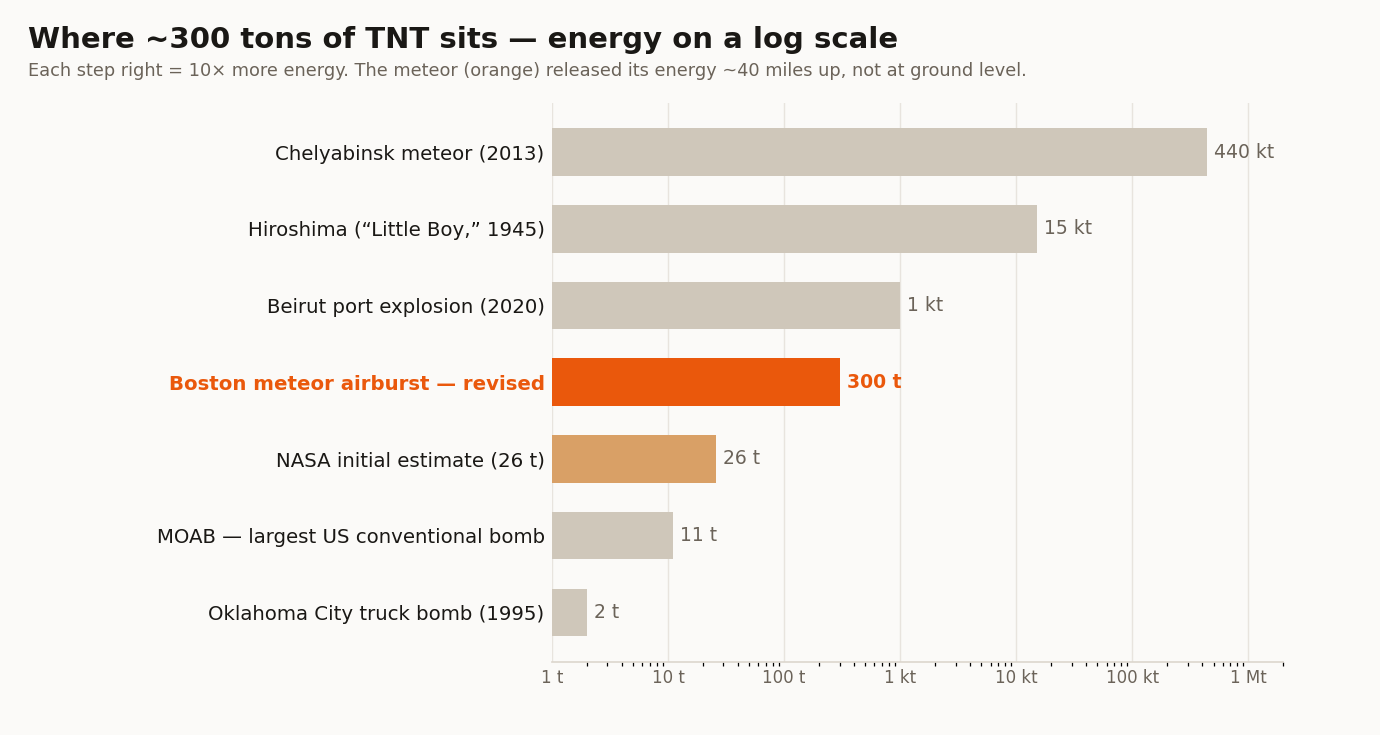
Log-scale bar chart comparing the meteor's ~300 tons of TNT to known explosions, from the 2-ton Oklahoma City bomb up to the 440-kiloton Chelyabinsk meteor.
Where ~300 tons sits. A log scale of energies people know. The meteor (orange) is ~27× the MOAB, ~150× the Oklahoma City truck bomb, noticeably smaller than the 2020 Beirut port blast, ~2% of Hiroshima — and ~1/1,500th of the 2013 Chelyabinsk meteor, which did shatter windows and injure ~1,500 people. Comparison values from public records; meteor figure from NASA via AP.3,4
vs. the biggest bomb

~27×

the MOAB (GBU-43), the largest conventional bomb the US has ever dropped (~11 tons each).

vs. a famous attack

~150×

the 1995 Oklahoma City truck bomb (~2 tons) — but spread 40 miles up, not at a curb.

vs. a nuke

~2%

of the Hiroshima bomb (15 kilotons). About one-fiftieth of an atomic weapon.

vs. the famous meteor

1/1,500

of the 2013 Chelyabinsk airburst (~440 kt). This was the baby version.

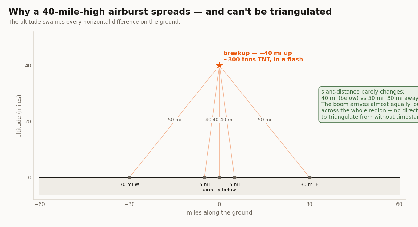
Geometry diagram showing the burst 40 miles up, with slant-distances to towns on the ground barely changing — 40 miles directly below versus 50 miles to a town 30 miles away.
Why the height is the whole story. Bursting ~40 miles up, the energy spreads across miles of open sky and dumps largely into light and heat. The same 300 tons at street level would level a city block. It also explains why the boom can't be triangulated: the slant-distance barely changes across the region (40 mi straight down vs. 50 mi to a town 30 mi away), so the sound arrives almost equally loud everywhere — there's no directional gradient to solve without millisecond timestamps. Diagram: first-principles geometry from the confirmed 40-mile altitude.
Crowd vs. authorities

Four maps, one meteor

The same event was independently mapped four ways — by a space agency, a government survey, a meteor society, and a crowd of strangers posting "did anyone else hear that?" Here's how a felt-map drawn from Reddit stacks up against the official instruments.

SourceMethodSampleWhere it points
Reddit — r/boston
this site's scrape
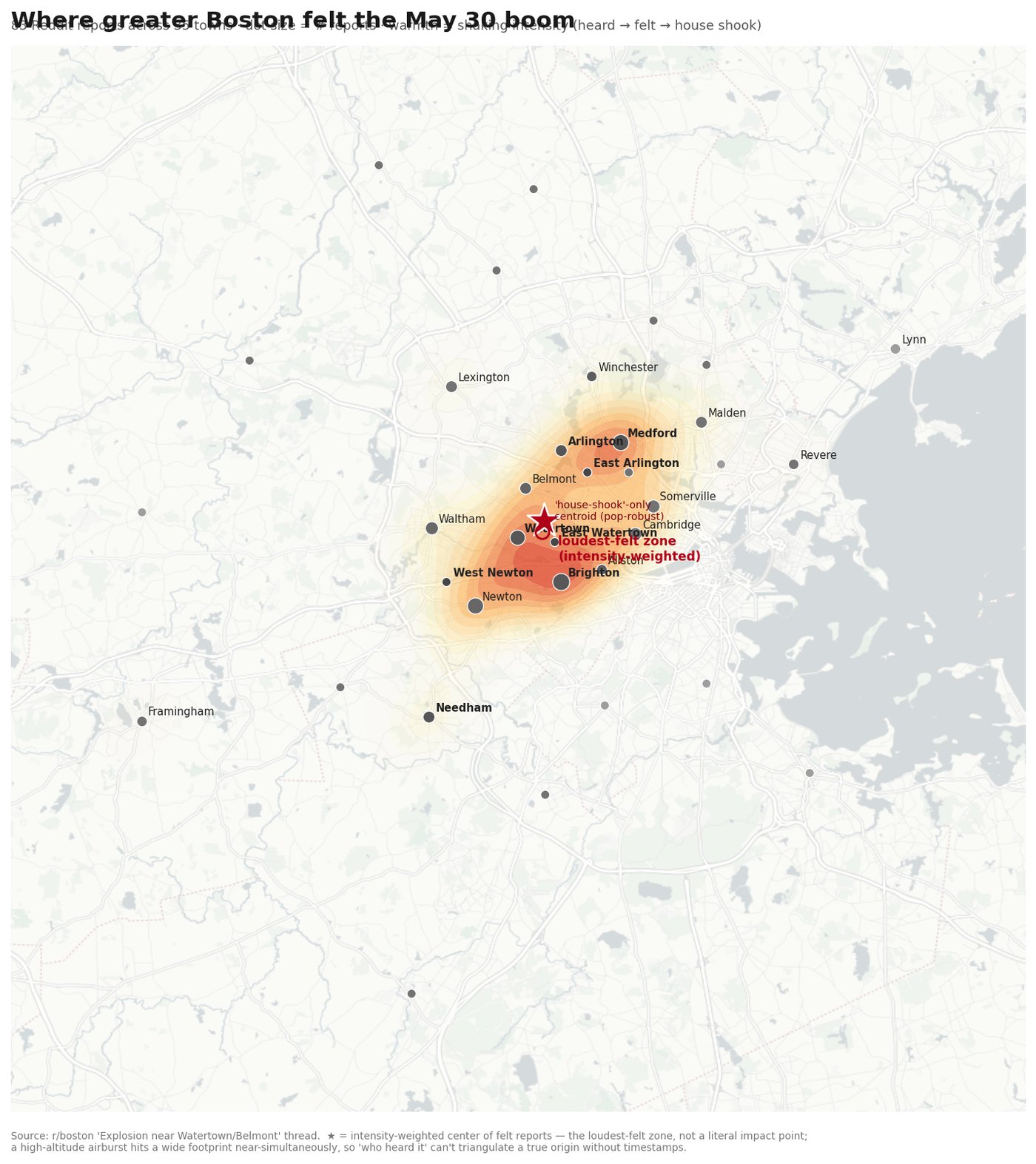
Felt reports, intensity-scored 1–335 towns / 83 reportsloudest-felt near Watertown/Belmont (42.379°N, 71.166°W)
Reddit — 12-thread
wider multi-subreddit sweep
Felt reports across r/boston, r/massachusetts, r/CambridgeMA66 towns / 501 commentsloudest-felt near Watertown/Newton (42.36°N, 71.15°W)
USGS "Did You Feel It?"
us7000spjy
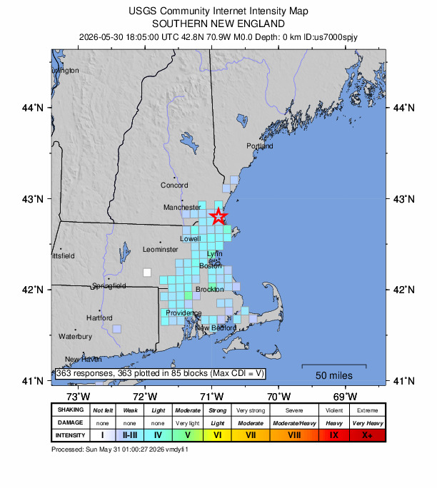
Geocoded felt reports, CDI363 reports, CDI 4.8felt-event assigned to Newburyport (42.8°N, 70.9°W)
American Meteor Society
#3867-2026
Eyewitness sightlines → trajectory49 reports, 10 states/provincestrajectory toward the NH/MA border
NASA (via AP)Sensors / fragmentation analysisfragmentation ~40 mi up, extreme NE MA / SE NH
Heat map of Reddit felt-reports across greater Boston, weighted by shaking intensity, with a loudest-felt-zone marker on the Watertown/Belmont line.
The crowd map. Built from r/boston reports, weighted by shaking intensity. The star is the loudest-felt zone — Watertown/Belmont. Data: r/boston thread; visualization computed from the felt reports.
USGS Community Internet Intensity Map for event us7000spjy, showing felt-intensity blocks across southern New England with the assigned event location starred northeast of Boston near the New Hampshire border.
The government map. USGS "Did You Feel It?" — 363 reports. Its assigned location (red star) sits northeast of Boston, near the NH line. Image: U.S. Geological Survey (public domain).1
American Meteor Society — live event page ↗

Event #3867-2026 · 49 eyewitnesses

The meteor society's instrumented record: 49 eyewitness reports from Delaware to Québec across 10 states & provinces, triangulated into a computed trajectory toward the NH/MA border. View their interactive sighting map and full witness list on the AMS site (their map is hosted there, not rehosted here).

Four methods, one corner of New England

A crowd of strangers, a government survey, a meteor society, and a space agency mapped the same event four different ways — and all four point to the same general area: the New England coast, northeast of Boston. They differ on the exact spot by tens of miles, which is what you'd expect. A meteor is a moving path, not a pin, and even the instruments place it differently along that track — NASA's fragmentation point, the USGS felt-center, and NOAA's parallax-shifted satellite flash all sit tens of miles apart.

So this page deliberately stops short of scoring "how close" any one map got. With the true breakup itself an uncertain region — still being refined — a precise miss-distance would be false precision. The honest takeaway is simpler, and still striking: four independent methods, built from very different data, independently fingered the same corner of the map.

How scientists pieced it together

From "what was that?" to "bolide" in an afternoon

On Saturday, May 30, 2026, the boom came before any explanation. For about an hour, the cause was an open question — earthquake, gas explosion, something military? Here's how seismologists, meteor scientists, and NASA ruled out the alternatives and converged on a meteor — in their own words.

First clue — it wasn't an earthquake. The shaking felt seismic, but the instruments that watch for earthquakes stayed silent. Whatever moved the air had come from the sky, not the ground.

"It must have gotten pretty far into the atmosphere. My automated system for detecting earthquakes didn't trigger."

John Ebel — senior research scientist, Weston Observatory, Boston College · Boston Globe

The U.S. Geological Survey found "no event registered on the agency's seismographs," and logged it as "a widely felt sonic boom from a suspected bolide… sonic boom events occur along a linear path in the atmosphere. No magnitude is assigned."

U.S. Geological Survey — event us7000spjy (spokesperson Steve Sobie; seismologist William Yeck) · USGS / AP

Then — a bolide, a fireball. With an earthquake ruled out, the science pointed up. A bolide is a meteor bright enough to flare like a daytime star and punch a shockwave through the air.

"It's a bolide meteor, which is essentially a fireball… The average size bolide meteor sits at 1–2 meters. NASA will ultimately estimate the size of this meteor in the coming days."

Ken Mahan — lead meteorologist, The Boston Globe · Boston Globe

Satellite imagery of the shockwave is "consistent with a good-sized meteor." "The sonic boom is a shockwave and, if intense enough, can be dangerous."

James Ryan — professor emeritus of physics, Space Science Center, University of New Hampshire · Boston Globe

"What you hear is the air compression of it moving really fast, creating those pressure waves — and… sometimes you're also hearing the stone itself break apart."

Shauna Edson — astronomy educator, Smithsonian National Air and Space Museum · CBS Boston

Finally — size, and where it went. The American Meteor Society, which logged 49 eyewitness sightlines, put a rough size on it and a likely fate.

"It was definitely bigger than a normal fireball, about a yard wide." "If it didn't burn up, then it would have landed in the ocean. Most of them do burn up before they hit the ground."

Robert Lunsford — Fireball Program Monitor, American Meteor Society · AP / CNN

NASA's analysis closed the case: a natural object — "not a re-entry of space debris or a satellite" — that broke up about 40 miles up, releasing energy first estimated at 26 tons of TNT and then revised the same day to ~300 tons. No active meteor shower. No ground impact. No injuries. Just a roughly three-foot rock (an estimate), a flash of light, and a boom that arrived in greater Boston about four minutes behind it.

Timeline

From boom to bolide, in an afternoon

2:06 PM EDT

The fireball enters over New England at ~75,000 mph (NASA). The flash is seen as a daytime "shooting star."

~2:07 PM

First eyewitnesses — who saw the daytime fireball — report to the American Meteor Society (event #3867, logged 18:07 UT = 2:07 PM EDT).

~2:10–2:11 PM

The sound catches up — ~4 minutes after the flash, because sound is far slower than light. Double booms and house-shaking pressure waves roll across greater Boston; "did you hear that?" threads erupt on Reddit (first post timestamped 2:10:40 PM).

Afternoon

USGS opens event us7000spjy; "Did You Feel It?" collects 363 reports. Seismographs show no earthquake → suspected bolide.

Same day

NASA (spox Allard Beutel) confirms a natural object, ~40 mi breakup. Energy estimate issued at ~26 tons, then revised up to ~300 tons of TNT.

That evening

Crowd-sourced felt-maps and the official USGS/AMS data are compared — all pointing to a breakup near the MA–NH line.

Primary sources

Every number, where it actually lives

Government and society data link to the .gov/.org primary. NASA's figures were issued as a statement carried by the wires, so they're cited "via AP/outlet" — no fabricated NASA URL.

1 · USGS (primary, public domain)
Event us7000spjy — executive "Did You Feel It?" felt map GeoJSON API (machine-readable)
363 reports · CDI 4.8 · suspected bolide · no earthquake.
2 · American Meteor Society (primary)
Event #3867-2026 — reports & trajectory AMS 2026 fireball-surge analysis
49 eyewitnesses · 10 states & provinces.
3 · NASA statement (via AP wire)
NBC News — AP wire (NASA figures) CNN — meteor sightings
2:06 PM · 75,000 mph · ~40 mi · natural object. NASA issued no public webpage; statement carried by wires.
4 · The 26→300 ton revision
GoLocalProv — Beutel's two emails, verbatim
The only outlet carrying both the initial ~26-ton and revised ~300-ton estimates.
5 · Size estimate + scientists
Boston Globe — local reporting & scientists CBS Boston — Lunsford "about a yard wide"
~3 ft is an AMS estimate (R. Lunsford), not a final NASA measurement.
+ · Crowd data
r/boston — original "explosion near Watertown/Belmont" thread
Felt reports scraped & intensity-scored for the crowd map.
Compiled May 30, 2026 from primary sources. Real images only: the data visualizations are computed from the cited figures, and the USGS felt map is the agency's own (public domain); the American Meteor Society's map is linked on their site, not rehosted. No imagery was generated or invented. Where the underlying figures are estimates or still firming up, the page says so.